Back Bodegraven Afrikaans بوديجراڤين ARZ Bodegraven Catalan Bodegraven CEB Bodegraven German Bodegraven Spanish Bodegraven Basque بودهخرافن Persian Bodegraven French Boadegraven Frisian
This article needs additional citations for verification. (May 2022) |
Bodegraven | |
|---|---|
Town | |
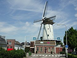
 Windmill De Arkduif | |
| Coordinates: 52°04′56″N 4°45′01″E / 52.0822°N 4.7504°E | |
| Country | Netherlands |
| Province | South Holland |
| Municipality | Bodegraven-Reeuwijk |
| Area | |
• Total | 26.58 km2 (10.26 sq mi) |
| Elevation | 0.7 m (2.3 ft) |
| Population (2021)[1] | |
• Total | 19,280 |
| • Density | 730/km2 (1,900/sq mi) |
| Time zone | UTC+1 (CET) |
| • Summer (DST) | UTC+2 (CEST) |
| Postal code | 2411[1] |
| Dialing code | 0172 |


Bodegraven (Dutch pronunciation: [ˈboːdəˌɣraːvə(n)] ⓘ) is a town and former municipality in the western Netherlands, in the province of South Holland. The former municipality covers an area of 38.50 km2 (14.86 sq mi) of which 1.02 km2 (0.39 sq mi) is water.
The former municipality of Bodegraven also includes the communities Meije, and Nieuwerbrug.
On January 1, 2011, Bodegraven merged with Reeuwijk to Bodegraven-Reeuwijk.
- ^ a b c "Kerncijfers wijken en buurten 2021". Central Bureau of Statistics. Retrieved 2 May 2022.
two entries
- ^ "Postcodetool for 2411AA". Actueel Hoogtebestand Nederland (in Dutch). Het Waterschapshuis. Retrieved 2 May 2022.


